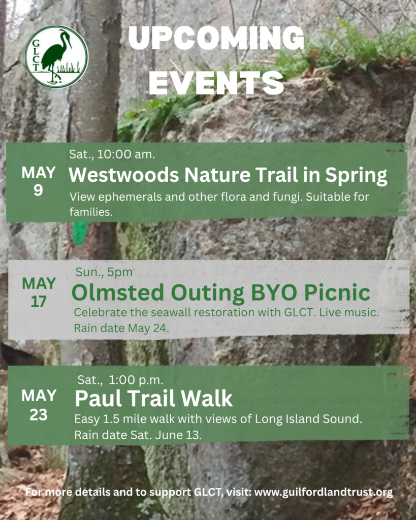
Welcome to the town of Guilford recreational trail system


RECREATIONAL
   Entrances
   Pictures
   Interactive Map

INFORMATION
   Map Availability
   Trail Blazes
   Rules
   Minutes
   Calendar
   Trail Descriptions

CONSERVATION
   History
   Get Involved

ABOUT US
   Web Development
   Contact People

WESTWOODS HOME

GLCT Website


The WestWoods trail system is the largest recreational area for hiking in Guilford. Westwoods contains 39 miles of trails on 1,200 acres. The ownership of the land is divided between State Forest, Guilford Land Conservation Trust (GLCT), City of Guilford and private ownership.

It contains a wide diversity of interesting natural formations such as: cave structures, water falls, salt and fresh water marshes, inland tidal lake, carved rock sculptures and rock formations.


GOOD NEWS! - The state has reopened the Westwoods trails system, but the list of the status of the trails should still be followed.


Due to the dead Hemlock trees in the Westwoods some of the trails have been closed down becaseof the likely event of falling trees. For an updated list of the trail status please download an excel spreadsheet (.exl), or an Adobe pdf file (.pdf).

Excel version Adobe pdf


Violet Circle - OPEN
Yellow Circle - OPEN
White Circle - OPEN
Orange Circle - OPEN
Green Circle - OPEN
Blue Circle - OPEN
Green Rectangle - OPEN
Blue Rectangle - OPEN
Green Triangle - OPEN
Yellow Triangle - OPEN
Red Triangle - OPEN
Red Square - OPEN
Red Diamond - OPEN
White Squares - OPEN
Orange Squares - OPEN South of Blue Rectangle CLOSED North of Blue Rectangle
Yellow Squares - OPEN
Cross Trails - CLOSED